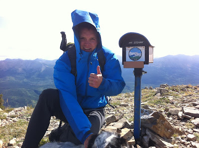
Today my wife Kate and I hiked Mount Stearn. It is an easy little day hike that is located near Grande Cache, Alberta, Canada. The Mount Stearn hike is part of the "Passport to the Peaks" program, a program that Grande Cache tourism has put in place that enables hikers to track and record the completion of their hikes within the area. Personally I find the program also gives the hiker a greater sense of achievement upon reaching the many regions summits. I will elaborate further on the program in a later post. Basically how it works is you summit a peak you get a stamp in your "passport", get all the stamps, and your awesome!
Mount stearn trail head is located a few km's up the sulphur gates road which is an easy road to find, only a short distance north of Grande Cache. Look for the small gravel pit directly across from the sulphur gates turnoff, and the distinct blue sign that marks the "Sulphur Gates" road. When you get to another small gravel pit slow down because the trail head is coming up. Park in the parking area to your left and you will see the distinctly cut trail traversing the side of the hill directly across the road.
The length of the hike is apparently debatable, due to the fact that the sign at the trail head states 6.5 km's one way while the Passport to the Peaks book declares it as 8.5 km's one way. My opinion on this is that because the approach to the summit is a scramble a variety of routes can be chosen, therefore the actual distance could definitely vary. For about the first 5 km's of the hike you are below tree line. It's also worth mentioning that you pass two small camp areas that look great for a winter camp! Although you are in the trees for just about two hours you gain elevation relatively quickly, making for a great payoff once you get up and out of the trees. Once up and out you hike a beautiful meadow that is periodically marked with pink survey tape. After a short trek through the meadow you will notice the tape will mark the turning of the trail. Follow the tape left, this is where the trail and tape disappear. Stay right and begin the accent up a wide ridge. Follow this ridge to the top where it will dip and then begin to rise again. From here if you look to your right you will notice a knoby summit. Look hard and you will spot a small figure that is the mailbox that holds the passport stamp. This is your final destination. After dipping down the ridge and back up you will come to a short rock face. Find an easy spot to scramble up, (their are a few), and then its a short walk to the left to reach the top. Boom! your done.
Using this route our ascent took us, and our border collie Jasper, just over three hours. I would say that it could defiantly be done a little quicker, we had some intense wind and the initial stages of a storm that slowed us up just before reaching the summit. Coming down took an hour and forty five minutes. In total this hike took just under six hours, that includes the half hour lunch and Jaspers numerous squirrel chasing tangents that I had to intervene upon.
Getting the Passport Stamped on the Summit!
When all is said and done I give this day hike 3.5 out of 5 stars on my day hiking scale. The payoffs are always great on these Grande Cache for the simple that you always summit. Also the excitement of the peaks program always gets me pumped to hike in the Grande Cache area. But because the Rocky Mountains are only just beginning in this area of Alberta, spectacles that up the payoff and overall experience such as towering mountains and glaciers are absent from the experience. These are the factors that drop the hikes grade for me As for a return trip, I would probably do this again with someone who hasn't done it before or like I said earlier, as a short winter overnighter. In the end I would have to to say, "I got my passport stamped and I am moving on to bigger and better things".
I will be posting more hikes that I have done throughout the past in later posts, so check back for more info! Also a Mountain Addict website is in the works! This site will go into greater detail on my adventures, so stay tuned because that should be up and running soon!
Here is a link to trail peak a credible websites that I use and consider valuable resource during the planning phase of my hikes. This is there review of the Mount Stearn hike.
http://www.trailpeak.com/trail-Mount-Stearn-near-Grande-Cache-AB-6112

No comments:
Post a Comment